Outlook Issued by NOAA for the First Three Months of 2019
Special Stories
20 Dec 2018 7:46 AM
NOAA's Climate Prediction Center has issued their outlook for January to March 2019, which still indicates patterns of a weak El Nino. Warmer than average temperatures are predicted across the West and Northern Plains. Colder than normal weather is predicted for the Tennessee Valley. From the Southeast to the Southwest, wetter than average weather is in the forecast. In the Ohio Valley and Pacific Northwest, below normal precipitation is predicted.
https://twitter.com/NWSCPC/status/1075748080547454977
The drought forecast for the start of 2019 continues to show improvement across California and the Rockies. With the drier than normal forecast for the Northwest, drought conditions are likely to develop over that region.
https://twitter.com/NWSCPC/status/1075750263275864064
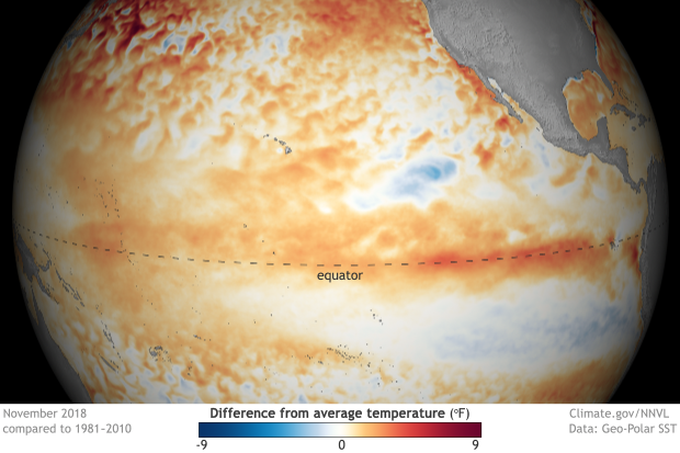
The extensively discussed El Nino is underway in the Pacific Ocean, but the atmosphere has yet to respond. Observed sea surface temperatures in the Pacific are warmer than normal as expected, with computer models expecting this to continue. Right now, the overall global pattern resembles neutral conditions. Based on the latest observations and model forecasts, the CPC still indicates a greater than 80 percent chance for El Nino from January to March and 70 percent that it persists through May.
 [November 2018 sea surface temperature departure from the 1981-2010 average. Graphic by NOAA Climate; data from NOAA’s Environmental Visualization Lab.]
For WeatherNation: Meteorologist Mace Michaels
 [November 2018 sea surface temperature departure from the 1981-2010 average. Graphic by NOAA Climate; data from NOAA’s Environmental Visualization Lab.]
For WeatherNation: Meteorologist Mace Michaels
[November 2018 sea surface temperature departure from the 1981-2010 average. Graphic by NOAA Climate; data from NOAA’s Environmental Visualization Lab.]
For WeatherNation: Meteorologist Mace MichaelsAll Weather News
More