New Citizen Science Projects Funded for Earth Studies
Special Stories
24 Apr 2018 9:55 AM
From NASA
NASA has selected six citizen science projects for full development that will provide the public with the opportunity to collect scientific data on air quality, bird populations, snowpack and other areas of NASA Earth science research.
The projects were selected from a group of 16 citizen science prototypes that received start-up funding from NASA’s Earth Science Division in 2017. Over the next three years, the six selected projects will transition from prototypes into mature citizen science projects supporting the collection of observations from the public that will be shared with scientists around the world as free, open data.
 Each project is led by a team of established researchers who will integrate voluntary public data and analysis contributions with observations from relevant NASA Earth-observing spacecraft and aircraft missions. “The projects merge the public’s enthusiasm in science with rigorous scientific methods necessary for understanding the global environment,” according to Kevin Murphy, program executive for Earth science data systems at NASA Headquarters in Washington.
“Each project links directly to NASA’s Earth science satellite missions and will help advance our scientific understanding of critical aspects of the Earth’s environment,” said Murphy. “Participation in these projects is not only fun, it helps improve data generated from NASA’s satellites.”
The projects selected are funded under NASA’s Citizen Science for Earth Systems Program for a total of $7.5 million over the next three years.
The six projects are:
 [A study of animal biodiversity led by California's Sonoma State University uses recordings of bird sounds and NASA satellite data to produce maps of species. Credits: Nicolas Grizzle, Sonoma State University]
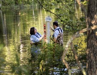 [Sarah Yelton (left) and project lead Tamlin Pavelsky of the University of North Carolina, Chapel Hill, take measurements near Chapel Hill to monitor changes in lake water storage. Credits: Johnny Andrews, UNC-Chapel Hill]
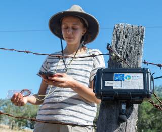
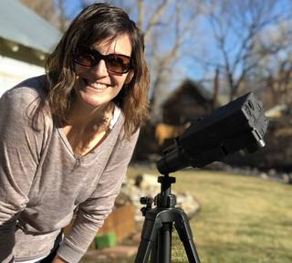 [A volunteer citizen scientist sets up an air quality sampler in her backyard as part of a Colorado State University-led project that measures small particulates in the air that can impact human health. Credits: John Volckens, Colorado State University]
NASA uses the vantage point of space to understand and explore our home planet, improve lives and safeguard our future. The agency’s observations of Earth’s complex natural environment are critical to understanding how our planet’s natural resources and climate are changing now and could change in the future. This information is freely and openly available to those seeking solutions to important global issues such as changing freshwater availability, food security and human health.
Edited for WeatherNation by Meteorologist Mace Michaels
 Each project is led by a team of established researchers who will integrate voluntary public data and analysis contributions with observations from relevant NASA Earth-observing spacecraft and aircraft missions. “The projects merge the public’s enthusiasm in science with rigorous scientific methods necessary for understanding the global environment,” according to Kevin Murphy, program executive for Earth science data systems at NASA Headquarters in Washington.
“Each project links directly to NASA’s Earth science satellite missions and will help advance our scientific understanding of critical aspects of the Earth’s environment,” said Murphy. “Participation in these projects is not only fun, it helps improve data generated from NASA’s satellites.”
The projects selected are funded under NASA’s Citizen Science for Earth Systems Program for a total of $7.5 million over the next three years.
The six projects are:
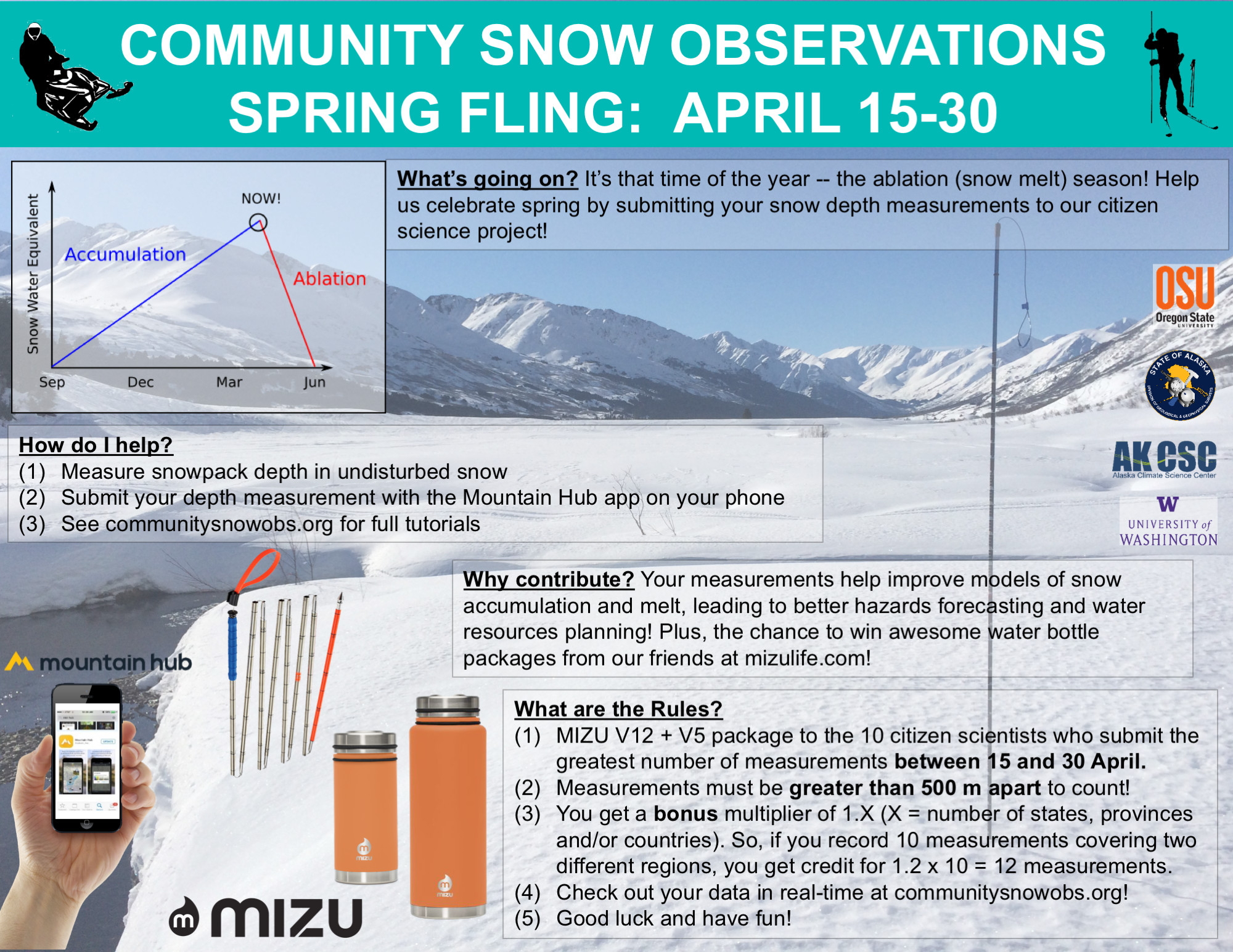
- Community snow observations – Anthony Arendt, University of Washington Applied Physics Lab, Seattle. Researchers, citizen scientists and industry partners collaborated in collecting community snow observations that were incorporated into NASA remote-sensing datasets and posted on a web-mapping service resulting in improved estimates of regional snow-water equivalence. Researchers will now increase recruitment and retention of citizen scientists, expand efforts to a broader region within the Pacific Northwest, and develop new web systems for smooth data flow between smartphone inputs and the laboratory.

- Global kelp cover – Jarrett Byrnes, University of Massachusetts, Boston. The “Floating Forests” project used Landsat satellite imagery and a new smartphone app to produce tens of thousands of new classifications from more than 1,000 unique users. Researchers will now expand the map of Floating Forests from the 1980s to the present, identify trends in global kelp cover and assess to what extent these changes may be related to climate change. New online tools and school curricula will also be developed to make it easier for citizen scientists and professional researchers to access the data.
- Animal biodiversity – Matthew Clark, Sonoma State University, Rohnert Park, California. The project conducted “bird blitzes” with citizen scientists who used their mobile phones to record bird sounds at 110 sites. The recordings were fed into a cloud-based acoustic analysis platform that combined bioacoustics analysis with NASA satellite data to produce maps of species’ presence and probability of occupancy. The project will now expand the area covered and look at how fires can impact bird communities.
 [A study of animal biodiversity led by California's Sonoma State University uses recordings of bird sounds and NASA satellite data to produce maps of species. Credits: Nicolas Grizzle, Sonoma State University]
- Low-cost air quality sensors – Prakash Doraiswamy, RTI International, Research Triangle Park, North Carolina. Using low-cost sensors deployed by citizen scientists in three regions representing low, moderate and high levels of fine particulate matter, researchers have helped improve aerosol measurements made by NASA satellites. The project will now enhance recruitment of citizen scientists and upload data to a flexible, open-source web portal.
- Water storage in lakes – Tamlin Pavelsky, University of North Carolina, Chapel Hill. To date more than 700 lake stage measurements have been taken by 76 citizen scientists and combined with imagery from NASA and European satellites for 11 ecologically and hydrologically important lakes in eastern North Carolina. Researchers will now create a globally accessible network to measure lake water storage variations in two or more regions a year.
 [Sarah Yelton (left) and project lead Tamlin Pavelsky of the University of North Carolina, Chapel Hill, take measurements near Chapel Hill to monitor changes in lake water storage. Credits: Johnny Andrews, UNC-Chapel Hill]
- Air quality measurements network – John Volckens, Colorado State University, Fort Collins. Researchers have developed a low-cost instrument used by citizen scientists to measure small particulates that pollute the atmosphere and can harm human health. These measurements have been coupled with NASA satellite data for more accurate findings and incorporated in a smartphone app that processes and displays user data on the web. The project will now improve the wireless capability of the sampler and seek efficiencies for collecting aerosol data around the globe.
 [A volunteer citizen scientist sets up an air quality sampler in her backyard as part of a Colorado State University-led project that measures small particulates in the air that can impact human health. Credits: John Volckens, Colorado State University]
NASA uses the vantage point of space to understand and explore our home planet, improve lives and safeguard our future. The agency’s observations of Earth’s complex natural environment are critical to understanding how our planet’s natural resources and climate are changing now and could change in the future. This information is freely and openly available to those seeking solutions to important global issues such as changing freshwater availability, food security and human health.
Edited for WeatherNation by Meteorologist Mace Michaels
[A volunteer citizen scientist sets up an air quality sampler in her backyard as part of a Colorado State University-led project that measures small particulates in the air that can impact human health. Credits: John Volckens, Colorado State University]
NASA uses the vantage point of space to understand and explore our home planet, improve lives and safeguard our future. The agency’s observations of Earth’s complex natural environment are critical to understanding how our planet’s natural resources and climate are changing now and could change in the future. This information is freely and openly available to those seeking solutions to important global issues such as changing freshwater availability, food security and human health.
Edited for WeatherNation by Meteorologist Mace MichaelsAll Weather News
More