Low Snowpack in the Colorado Rockies Sparks Concern
Special Stories
17 Jan 2018 1:06 PM
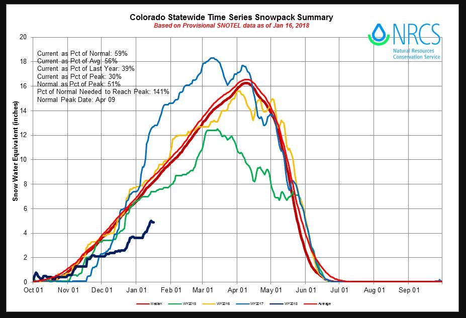
When you think of winter in the Colorado Rockies, one word comes to mind, snow! It's seems like a given that snow flies in the Rocky Mountains from November through April. But so far, snow has been rather scarce in most of Colorado. And snow season has already reached the half-way point. This has created some concern, because winter snow, becomes spring runoff, which is how Colorado gets its water supply. A snowy winter, also lessens the danger of wildfires during the dry summer months. And snow is the life-blood of ski resorts. For all of these reasons, snow is king in Colorado. The latest numbers are in, and they're not good. Snow levels are currently at 59% of normal. And levels are only 39% compared to where they were at the same time last year. Some areas are reporting the driest start to a winter in over thirty years.
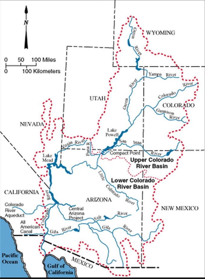
 Snowpack in the Colorado, Wyoming, and Utah mountains also feeds the Colorado River basin. All of the Colorado River's upper basin streams empty into Lake Powell. This reservoir, on the Utah-Arizona boarder, serves as a vital water supply for seven states, including Arizona, California, Colorado, Nevada, New Mexico, Utah, and Wyoming. It's water irrigates 1.8 million acres of farm and ranch land. The river basin also provides the water supply for 40 million people in the southwestern U.S.
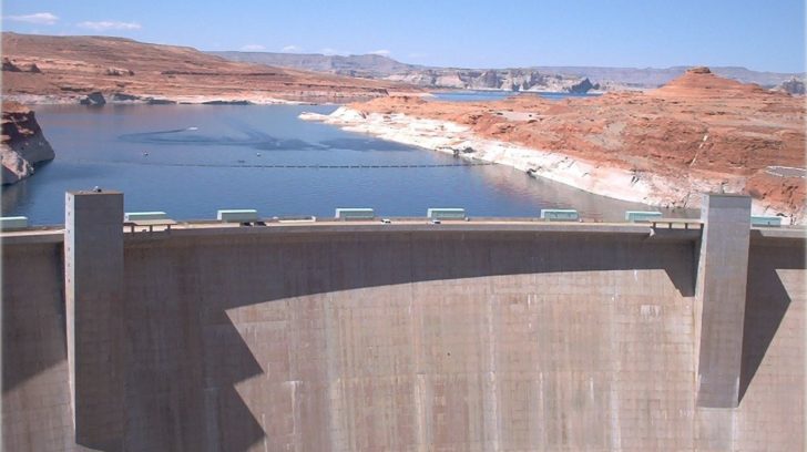 The Glen Canyon Dam holds back the water of the Colorado River to form Lake Powell. Water flow through this dam provides electric power to Native American reservations and towns throughout Utah, Colorado, Arizona and New Mexico. The dam also provides critical water supply for agricultural operations, allowing the arid Southwest to become fertile agricultural land for fruit and vegetable crops. You can see in the map below, how the Green, Yampa, Gunnison, and Colorado rivers all flow into Lake Powell. And all of these rivers flow because of snow-melt from the Rockies.
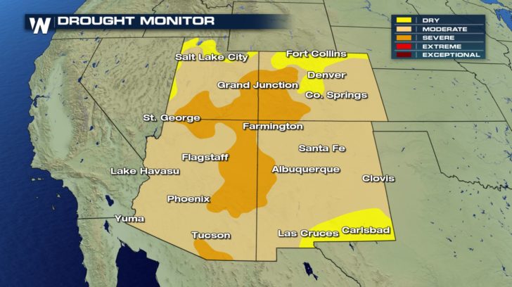
 The Four Corners region needs moisture, and it needs to rebound strong in the second-half of the winter to make up for a lack-luster first-half. However, the prognosis is not good. Most of the region is already in a moderate to severe drought, and the situation will only worsen if rain and snow don't arrive in abundance.
 Most of the rain and snow this season have been in the northwest. Washington, Oregon, Idaho, and Montana have seen plenty of moisture this winter. Why is this? One reason may be La Niña, which is characterized by unusually cold ocean temperatures in the Equatorial Pacific. This change in ocean temperatures can drastically alter weather patterns across the U.S.
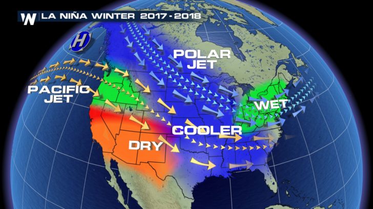 The La Niña set-up has led to plenty of moisture in the northwest, and a lack of moisture in the southwest. This has long range forecasts calling for less than 50 percent of average snowfall for the remainder of the winter. But there's no need to panic quite yet. Snowpack the last couple of years has been average or above average in the Rocky Mountains. Many of the region's larger reservoirs have the capacity to withstand a dry year. And the Upper Green River Basin in Wyoming has above snowpack this season, along with portions of the Colorado River's headwaters in Rocky Mountain National Park. So it's not all doom and gloom quite yet. But more snow would certainly be a great thing for all concerns, including skiing!
For WeatherNation: Meteorologist Matt Monroe
 Snowpack in the Colorado, Wyoming, and Utah mountains also feeds the Colorado River basin. All of the Colorado River's upper basin streams empty into Lake Powell. This reservoir, on the Utah-Arizona boarder, serves as a vital water supply for seven states, including Arizona, California, Colorado, Nevada, New Mexico, Utah, and Wyoming. It's water irrigates 1.8 million acres of farm and ranch land. The river basin also provides the water supply for 40 million people in the southwestern U.S.
 The Glen Canyon Dam holds back the water of the Colorado River to form Lake Powell. Water flow through this dam provides electric power to Native American reservations and towns throughout Utah, Colorado, Arizona and New Mexico. The dam also provides critical water supply for agricultural operations, allowing the arid Southwest to become fertile agricultural land for fruit and vegetable crops. You can see in the map below, how the Green, Yampa, Gunnison, and Colorado rivers all flow into Lake Powell. And all of these rivers flow because of snow-melt from the Rockies.
 The Four Corners region needs moisture, and it needs to rebound strong in the second-half of the winter to make up for a lack-luster first-half. However, the prognosis is not good. Most of the region is already in a moderate to severe drought, and the situation will only worsen if rain and snow don't arrive in abundance.
 Most of the rain and snow this season have been in the northwest. Washington, Oregon, Idaho, and Montana have seen plenty of moisture this winter. Why is this? One reason may be La Niña, which is characterized by unusually cold ocean temperatures in the Equatorial Pacific. This change in ocean temperatures can drastically alter weather patterns across the U.S.
 The La Niña set-up has led to plenty of moisture in the northwest, and a lack of moisture in the southwest. This has long range forecasts calling for less than 50 percent of average snowfall for the remainder of the winter. But there's no need to panic quite yet. Snowpack the last couple of years has been average or above average in the Rocky Mountains. Many of the region's larger reservoirs have the capacity to withstand a dry year. And the Upper Green River Basin in Wyoming has above snowpack this season, along with portions of the Colorado River's headwaters in Rocky Mountain National Park. So it's not all doom and gloom quite yet. But more snow would certainly be a great thing for all concerns, including skiing!
For WeatherNation: Meteorologist Matt Monroe
The La Niña set-up has led to plenty of moisture in the northwest, and a lack of moisture in the southwest. This has long range forecasts calling for less than 50 percent of average snowfall for the remainder of the winter. But there's no need to panic quite yet. Snowpack the last couple of years has been average or above average in the Rocky Mountains. Many of the region's larger reservoirs have the capacity to withstand a dry year. And the Upper Green River Basin in Wyoming has above snowpack this season, along with portions of the Colorado River's headwaters in Rocky Mountain National Park. So it's not all doom and gloom quite yet. But more snow would certainly be a great thing for all concerns, including skiing!
For WeatherNation: Meteorologist Matt MonroeAll Weather News
More